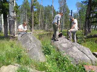
Anders wielding his three pound sledge hammer.
Quartzite boulder in a farm yard.
Alberta pasture at Cheddervile with Aspen trees
Boulders in the pasture with the cattle soon to return.
Boulders in a grove of Aspens in the pasture
Heather measuring a boulder across the road from the farm.
Farmers built the fence around the boulder.
We spent Tuesday night at a camp ground in Caroline, Alberta
on the prairie about 60-70 kilometers from the Front Range and about 150
kilometers north of Calgary. One of the
challenges in locating boulders is to guarantee that they were not previously
covered by water or sediment from the outwash that resulted from the melting of
the ice sheets. To correct for this
possibility boulders from ridges assures that nothing has happened to them
since they were deposited. So we headed
toward the Front Range to their foot hills where ridges abound. Now the ridges
are timbered and logging is taking place in various areas. We had used Google Earth and seen a number of
logging roads that would provide great access into the back country. Much of this land is Crown land which means
it is assessable to the public. Looking
for boulders in timbered landscape is really hard work, so the prospect of an
open landscape is greatly appreciated.
Were we in for a surprise? We had
hoped to drive down these logging roads – no way. The loggers had dumped about 2 to 3 foot of
sand and gravel at the entrances to these roads. Furthermore, the active roads were blocked
with 3 3 foot chained cement blocks and chained. We used binoculars to look up the sides of
the slopes in two areas but no boulders were to be seen and with all the
logging roads blocked we came up short for trying to collect on the
ridges. So you might be wondering why no
boulders when we had been so successful yesterday. These ridges are made up of carbonate rocks
like dolostone and limestone. These are
softer rocks than quartzite and the rocks would consequently break into smaller
boulders when carved by an ice sheet.
Furthermore being a softer rock the limestone boulder would weather,
breakdown faster than a quartzite boulder.
So we struck out this morning, but if you don’t look you won’t know.
We headed back east to the prairie around Chedderville. The hummocky prairie is actually a till
plane. We again asked ranchers for
permission to collect on their property.
We knew of several boulders because samples were first collected by Lionel
Jackson in the mid 1990’s and recorded in a now “classic” paper. This till plane is a melted ice feature from
the Cordilleran Ice Sheet lain down as it flowed out of the mountains east, hit
the Laurentide Ice Sheet, and turned to the south. There are no kettles and is similar to the
till plains or rolling countryside of southern Wisconsin. To the casual observer Chedderville, Alberta
is a till plain, a picturesque green pasture with groves of aspens, Dutch clover,
buttercups, bluets, and lupines. The
cattle herd was by chance still in the cattle yard when we arrived. They immediately began to watch us at a
distance. They bawled a bit, lecturing
us, in spite of their uncontrolled curiosity.
We were concerned that possibly the boulders we would find would have
been moved by the ranchers when clearing their fields. This was not grazing land here. Here also small grains are grown. Till plane boulders could give a false
reading. They possibly could have been
covered by sediment and then “more recently” exhumed by weathering or frost
heave, giving an unusually young false reading.
Our efforts were most productive. We collected 12 samples from this farm. The farm had been in the family for 100
years. The farmer told us about enormous
boulder down the road where his mother had played as a little girl. We located that boulder. It would have been our lucky thirteenth
sample, but we left it out of respect for his mother.


